August 2018, Vol. 245, No. 8
Tech Notes
Activity Monitoring for Damage Prevention, Risk Reduction
A big goal of transmission companies is to reduce risks and improve the safety of affected communities through an integrity program that ensures construction quality of the pipeline, monitor the longevity of pipeline materials, educate the public, and apply damage prevention systems to avoid third-party damage to pipelines.

The urban encroachments along pipeline corridors have created a higher probability of third-party damage to pipelines, especially with shale developments in and around communities.
Pipeline safety processes consist of several preventive measures such as pipeline markers, periodic surveillance of rights-of-way (ROW) and the One-Call System to locate their utility lines prior to excavation.
However, these precautionary programs rely primarily on the promotion of pipeline precautions and local building governance to protect assets. Pipeline LandWatch (PLW) is a monitoring system that uses data sources to identify impending exposure to a pipeline.
The monitoring services notify property owners of planned activities such utility excavation that would expose landfilled materials, and PLW is an adaptation of this technology. Once active, this system continuously monitors, alerts and notifies operators of potential threats, providing a longer time horizon to proactively eliminate these threats.
PLW monitors land activities along pipeline corridors, applying information technology to help protect the safety of a pipeline. The program searches and sifts the “electronic trail” of hundreds of land transactions and land activities to monitor and help prevent third-party risks by providing operators lead time to develop contingency plans and communicate pipeline precautions to proper stakeholders.
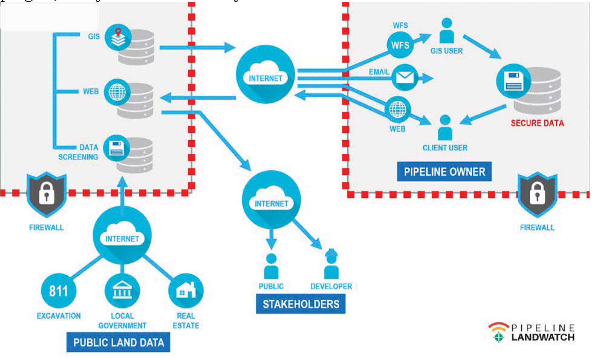
This data subscription service is a “plug-in” to enterprise geographic information systems (GIS), damage prevention and ROW management systems. It creates or is configured into existing workflows to provide a dashboard and alert process that monitors and notifies the operator of potential risks along the ROW.
The lead time of planned activities will allow operators to proactively manage the risks by communicating with developers and contractors to promote safety and a higher level of operational efficiency.
The system can be the communication bridge between pipelines and city planners who are reviewing developments, including land disturbances, road expansions and utility relocations.
Service Activation
This web-based subscription flags future land activities along a pipeline and augments existing public awareness and damage prevention programs. The monitoring system is easy to install, since the monitoring service covers a wide swath over the pipeline’s buffer zone, and a general location of the centerline is all that’s needed to start the activation. The system setup requires security authorization to permit user’s access to the web-based system.
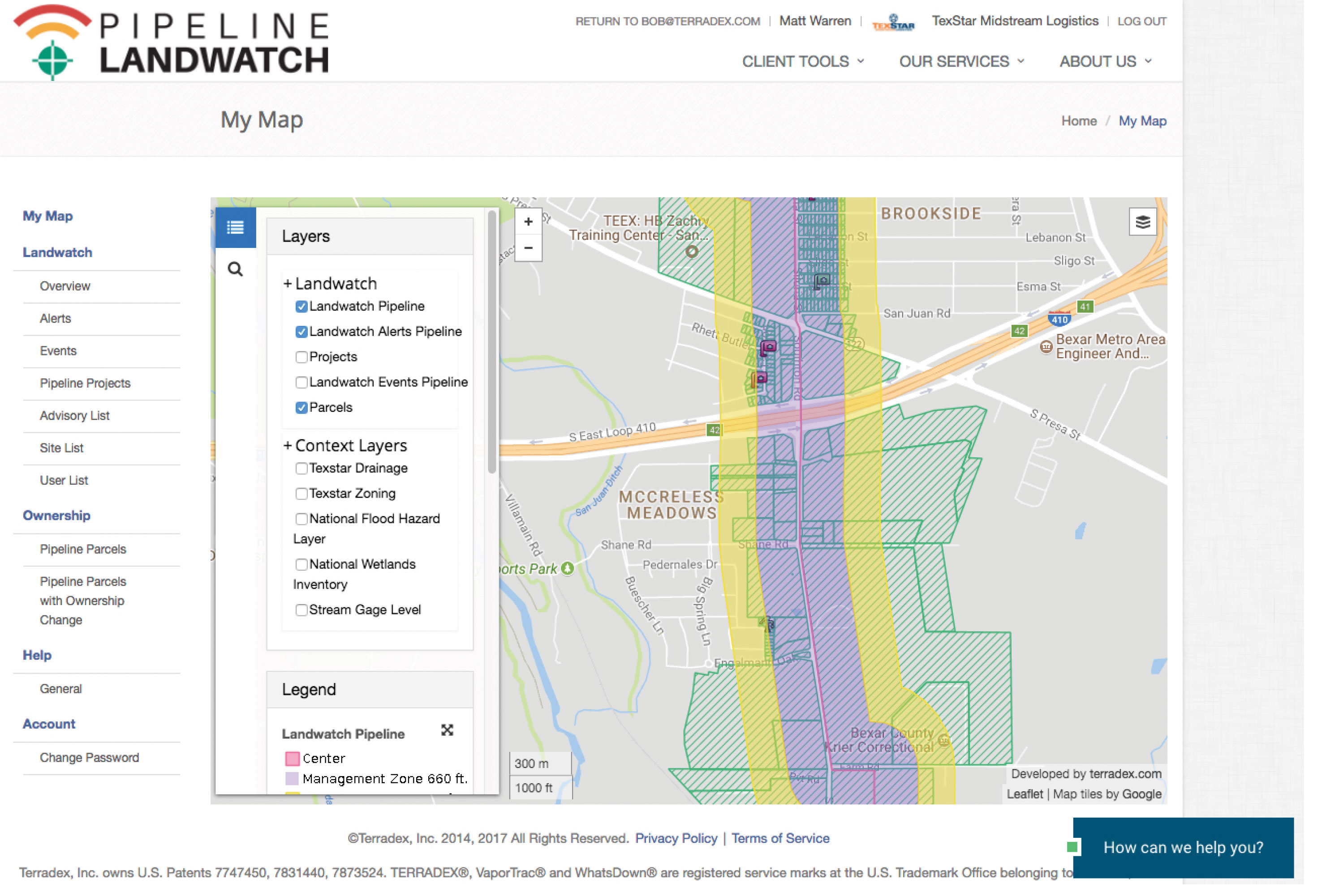
The system overlays a coverage outline over the pipe’s protective buffer zone including pipeline, and operational assets. The width of the protective buffer zone is dependent on specific operations, population density and sensitive environmental criteria. Information is extracted from different data sources and provided as layers on a GIS map.
The GIS layers are depicted spatially and managed on an intuitive, real-time system dash board. The user can prioritize information layers. Example layers are new property transactions, zoning changes, building permits, road expansions or realignments, building occupancy and drainage pattern changes. In addition, new monitoring data layers can be developed to fit specific risks identified such as stream levels at water crossings, the threat of forest fires and earthquake seismic influences near a pipeline.
The monitoring service provided by PLW also allows pipelines to provide automatic public awareness messaging using the same buffer zone coverage to provide advisories to property owners or local and regional stakeholders. It uses a variety of social communication media such as phone calls, emails, and texting.
These communications can alert new property owners along a pipeline to digging precautions prior to land disturbances. Similarly, the service provides communications to agriculture property owners prior to seasonal crop management to remind farmers and ranchers to pipeline locations and to use 811 Call System prior to land activities.
The alert configuration controls how stakeholders along the pipeline are contacted automatically by the operator through the PLW service to provide reminders, messages and pipeline alerts.
GIS is a key component of most pipeline integrity management. Multiple data elements can be served to GIS systems as a web map service (WMS) or a web feature service (WFS). The service augments infrastructure information with near real-time actionable land activities data. The value is through a simple data service plug-in, easily accommodated by most GIS teams.
The subscription data service that can monitor activity on and around pipelines and related facilities. It’s designed to augment existing company processes and enterprise systems, offering efficiency to limited manpower resource. This provides leverage to existing IT and data infrastructure. P&GJ


Comments